Background
With large volumes of spatially related data commonly residing across a range of disparate siloed systems that potentially have a high rate of change, the traditional paradigm of requesting spatial analysis from subject matter experts and waiting for their responses in hours, days or weeks simply does not cut it.
By the time the spatial analysis is completed and the results are provided (often from multiple business areas), the answers are often incorrect, out of date or irrelevant.
In many cases, users have a limited understanding of the actual links and relationships between different spatial data sets and don't know what questions to ask in the first place.
Conventional geospatial tools are typically too complex for non-specialist users meaning the majority of people cannot self-serve and find the answers they need for themselves. In addition, they're typically driven by "batch" process instead of real-time data, making it impossible to get up to the minute answers.
The Elafent Cloud Platform (ECP) massively simplifies this process and takes the complexity out of spatial correlation and analysis so everyone can get up to date answers and gain valuable insight into the relationships between spatially related data sets.
Operational Challenges
Understanding the relationship between spatial data sets is a challenging exercise and often unachievable for non-specialist users. In many cases, staff -
Rely on subject matter experts (SMEs) to perform spatial analysis and answer spatial queries using specialist geospatial tools
Receive information that has become incorrect, out of date or irrelevant during the time they have waited for SMEs to perform the spatial analysis as critical spatial data changes
Burn cycles defining requirements for what they think they need to know so SMEs can prepare the necessary spatial outputs for them
Are unaware of the potential links and relationships between different spatial data sets and simply don't know the right questions to ask SME's and in turn, miss out on valuable insight.
Customers and community members are often in the same boat, struggling to understand the relationships between spatial datasets which could impact them, the wider community, their business or their family and friends and revert to contacting the call centre when they can't get the information they need.
Many specialist geospatial tools -
Are too complex for non-specialist users, customers and community members to access
Are too expensive to roll out to a larger user base across the greater organisation or to make available to customers and/or the community
Only perform spatial analysis on limited subset of operational data and are not designed to utilise a heterogeneous mix of data from disparate siloed systems
Struggle to handle data changing at a high velocity and provide static outputs which don't dynamically update and in turn become obsolete and need to be created again every time a user requests the information
Require a lot of heavy lifting to take advantage of external spatially related data sets from peer organisation or external service providers
Are not been designed from the ground up to work on mobile devices and as such, can be difficult for users to access in the field.
These limitations can lead to -
Valuable operational insight getting lost and not taken advantage of
Critical decisions being made on incomplete or out of date information
Increased load on call centre staff
SMEs being inundated by spatial information requests
Reduced efficiency and resolution times
Increased operational costs
Frustrated workers and customers.
Operational Optimisation
The Elafent Cloud Platform (ECP) takes the complexity out of spatial correlation and analysis by providing a powerful capability everyone can use to gain seamless and unprecedented insights into masses of spatially related data.
Key elements of this capability include -
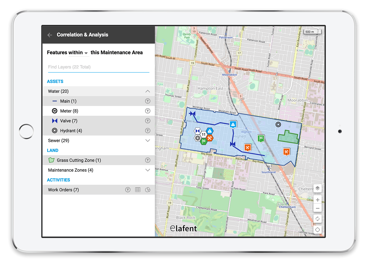
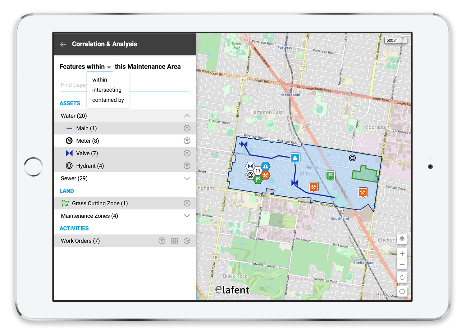
Simple to use, intuitive user experience enabling non-specialist and specialist users alike to gain valuable insight into the relationships between spatial data by performing powerful spatial and analytical queries such as -
Within - identifying all the spatial features which exist within a specific area of interest (polygon)
Intersecting - identifying all the spatial features (points, polygons, lines) which intersect with a specific feature of interest
Contained by - identifying the parent features (polygons) that bound a specific feature of interest
Data driven correlation and analysis providing immediate insight into the spatial relationships which exist between datasets without users having to know these relationships beforehand or cycle through countless datasets searching for a relationship that does not exist
Dynamic data support ensuring the results of spatial correlation and analysis automatically update to reflect any changes in the underlying data, so users always get correct and up to date answers to their queries
Spatial correlation and analysis with a 360-degree view enabling a large variety of data from disparate siloed systems and external data sources to be spatially correlated, analysed and viewed in relation to other information as part of a complete operational picture
iOS and Android Support enabling spatial correlation and analysis to be performed in the field via a heterogeneous mix of devices as required by staff, contractors and peer organisations.

Business Impact
The Elafent Cloud Platform (ECP) breaks down the technical, usability and budgetary barriers associated with spatial correlation and analysis, so everyone can gain valuable insights across masses of spatially related data. Benefits include -
Greater levels of operational insight
Improved quality of operational decision making
Reduced load on subject matter experts/specialist users
Increased efficiency
Reduced costs
Less frustrated workers, customers and community members.